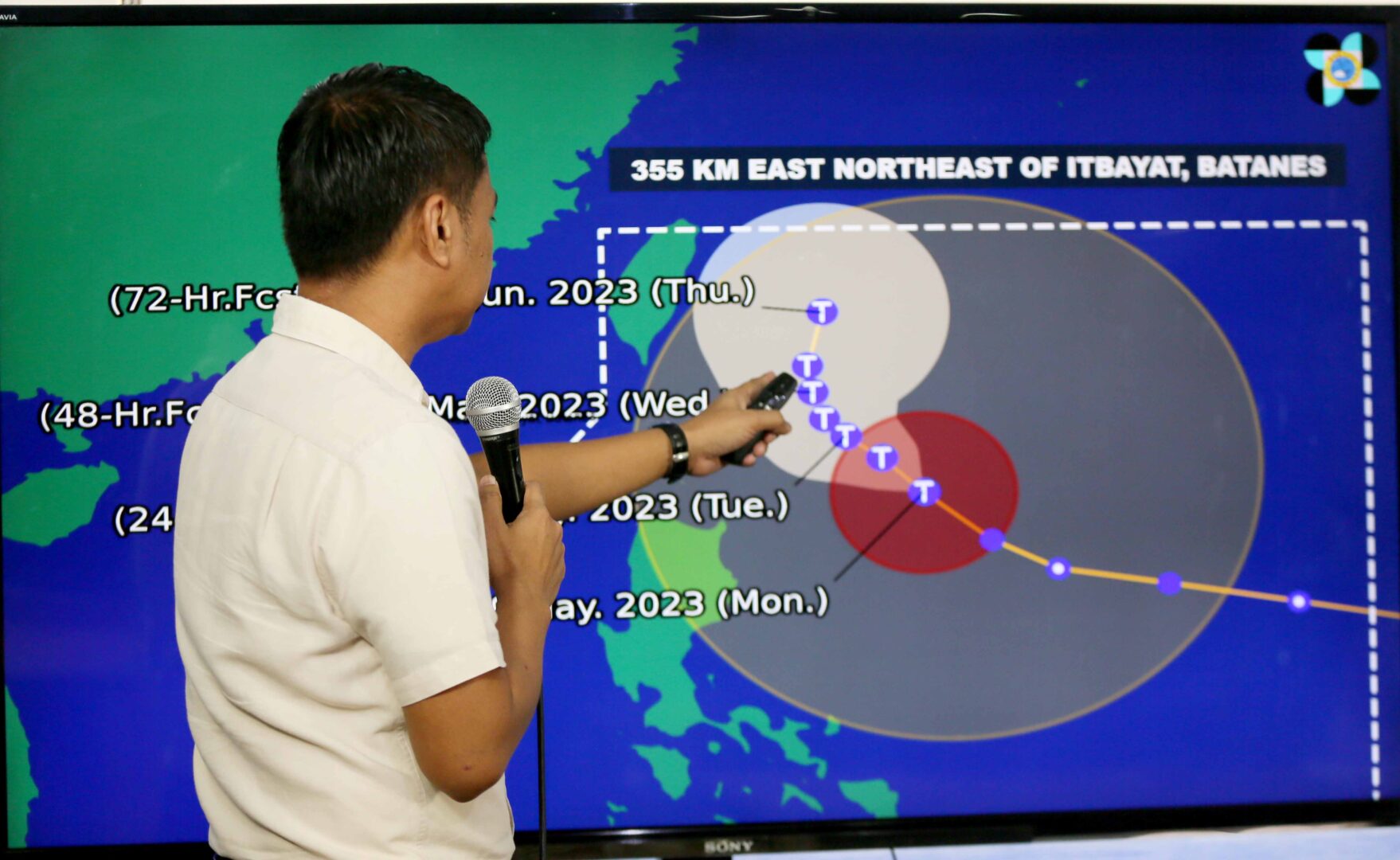
Typhoon ‘Betty’ is likely to enhance the southwest monsoon or habagat in the next three days while heavy rains will prevail in parts of the country, according to the Philippine Atmospheric, Geophysical and Astronomical Services Administration.
In its latest weather bulletin, PAGASA said the typhoon slightly decelerated while moving northwestward over the waters of Cagayan. Rainfall accumulating from 50 to 100 millimeters is expected in the eastern portion of Babuyan Islands and the northeastern portion of mainland Cagayan on Tuesday.
Batanes and the eastern portion of Babuyan Islands will experience 100-200 mm of rainfall from Tuesday morning to Wednesday morning while 50-100 mm will fall in the rest of the Babuyan Islands, the northern portion of mainland Cagayan, Ilocos Norte, Ilocos Sur, La Union, Abra and Benguet.
The forecast accumulated rainfall from Wednesday morning to Thursday morning is 100-200 mm over Batanes, the southern portion of Ilocos Sur, La Union, and the western portion of Benguet.
Pagasa assistant weather services chief Chris Perez said tropical cyclone wind signal 2 or strong winds is hoisted over Batanes, the northeastern portion of Cagayan and Babuyan Islands, with minor to moderate impacts caused by gale force winds within these areas likely.
As the typhoon starts to enhance the southwest monsoon, Perez said occasional gusts are possible in the next 24 hours over localities in the eastern portion of Central Luzon, eastern and southern parts of Southern Luzon that are not under any wind signal, and most of the Visayas — more likely in the coastal and exposed upland or mountainous areas.
The southwest monsoon or habagat is warm moist winds from the southwest causing rains over the western portion of the country from May to September.
Under the influence of “Betty,” PAGASA said a marine gale warning remains in effect over the northern and eastern seaboards of Northern Luzon, eastern seaboards of Central Luzon, the eastern and southern seaboards of Southern Luzon, the eastern and western seaboards of the Visayas, and the eastern seaboard of Mindanao.
The center of the eye of “Betty” was last tracked at 470 km east of Aparri, Cagayan, or 475 km east of Calayan, Cagayan.
It was moving generally northwestward slowly on Monday and will become slow moving or almost stationary Tuesday to Wednesday while traversing over the waters east of Batanes.
The typhoon will turn north-northeastward or northeastward late on Wednesday or Thursday and gradually accelerate towards the waters east of Taiwan and the southern portion of the Ryukyu Islands.
Pagasa said “Betty” may exit the Philippine Area of Responsibility on Friday and is forecast to steadily weaken over the next five days due to dry intrusion and cooler ocean waters caused by an upwelling of cooler waters in its wake.
“Betty” may be downgraded to a severe tropical storm on late Thursday or early Friday and to a tropical storm on late Friday or early Saturday.
Standby fund
Amid the weather condition, the National Disaster Risk Reduction and Management Council said around P352-million was on standby from the Office of Civil Defense, consisting of a Quick Response Fund amounting to P244.7-million and P108.2 million worth of prepositioned non-food items.
OCD administrator and NDRRMC executive director, Undersecretary Ariel Nepomuceno, said these funds were ready for distribution to assist the affected communities.
“Other government resources are also on standby, including our equipment for emergency telecommunications and transportation assets, among others,” he added.
The Department of Social Welfare and Development said it has a total of P2.2 billion for stockpile and standby funds.
Also, the country’s latest adjusted balance for the National Disaster Risk Reduction and Management Fund for the rehabilitation of calamity-hit communities is at P18 billion, according to the Department of Budget.
Meanwhile, the Civil Aviation Authority of the Philippines has released the following updates on various regional airports in Area Centers 1 and 2.
In Area 1 airports (Baguio, Laoag, Lingayen, Rosales and Vigan), the weather is often favorable. However, the Cebu Pacific and Philippine Airlines flights at Laoag International Airport have been canceled.
Additionally, the Cebu-Baguio PAL flight has also been canceled, according to Area Center 1 Manager Ronald Estabillo.
According to Area Center 2 Manager Mary Sulyn Sagorsor, as of 3 a.m. yesterday moderate rain and winds were experienced at Tuguegarao Airport. However, no damage to life or property was reported. As of 7 a.m. the sun was up, indicating improving weather conditions.
Canceled flights
The following flights operated by Cebu Pacific in Area Center 2 were cancelled: Manila-Tuguegarao-Manila, Tuguegarao-Basco, Tuguegarao-Calayan
Basco Airport reported moderate winds with no rain yet. Due to typhoon “Betty,” work in all government offices in Basco had been suspended until further notice, as per Municipal Executive Order 65.
At Cauayan Airport, the Manila-Cauayan-Manila Cebu Pacific flight was canceled, as with coastal flights.
According to an advisory from Cebu Pacific, its Manila-Masbate-Manila flight was also canceled.
CAAP reminded passengers to prioritize their safety and cooperate with airport and airline authorities during the weather disturbance. Travelers were advised to contact their airlines for any changes to their flight schedules, alternative arrangements, or further information.
CAAP Area Center personnel and airport managers were closely monitoring the situation and were advised to provide timely updates as necessary.
